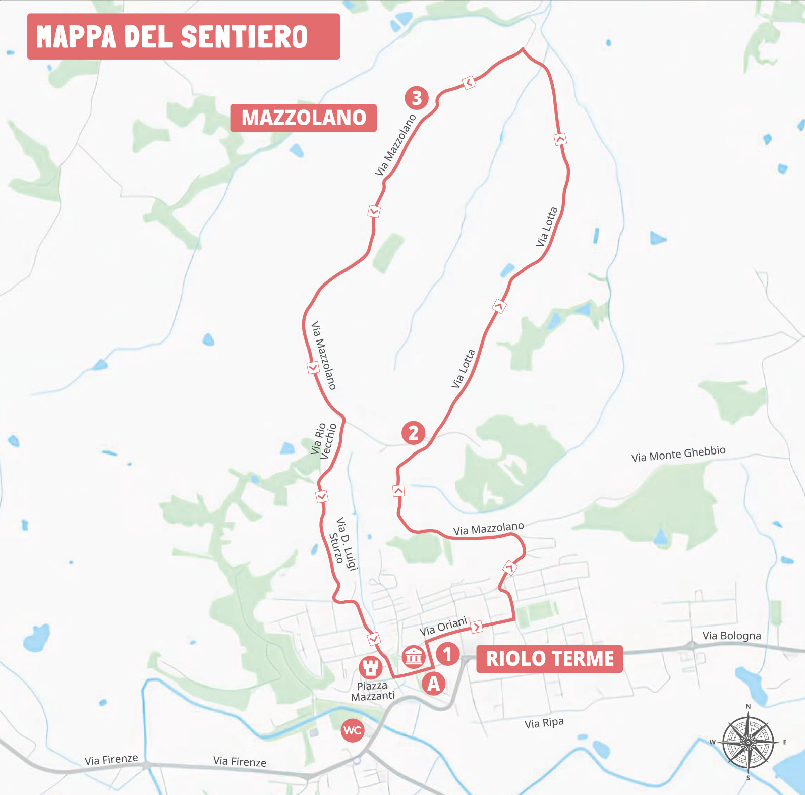
This route is part of the official hiking network "I Petali della Ginestra" of Riolo Terme. The itinerary runs near the Regional Park of the Vena del Gesso Romagnola, a UNESCO World Heritage Site recognized for the geological significance of its evaporite karst landscape in the Northern Apennines.
This loop route winds along scenic roads on the northern side of the Vena del Gesso Romagnola, connecting the town of Riolo Terme with the hamlet of Mazzolano.

-
Starting from the Historic Village
Starting from the Riolo Terme Town Hall (Via Aldo Moro 2), the route reaches the Church of San Giovanni Battista, where you can admire Sante Ghinassi’s large majolica Crucifixion and Angelo Biancini’s Via Crucis. From here, continue to Parco Pertini, a green area that is an important meeting place for the local community.
-
Towards the Hills
Leaving the town centre, the route follows Via Mazzolano and continues along Via Lotta, where you will find the Monument to the Portaferiti, dedicated to the rescuers who, during the Second World War, transported wounded soldiers along this road towards the hospital in Imola. From here, you can enjoy panoramic views over the valley. Continuing northwards, you reach the Church of San Martino di Mazzolano, built in the 19th century on the remains of a medieval foundation. From here, continue along the path on the right towards Mezzacosta, passing through vineyards and orchards before descending back towards the village centre.
-
Thermal Landscapes
From around kilometre 7, the descent offers wide views over the Rio Vecchio badlands, among clay landscapes and broom-covered slopes, with breathtaking views of the Middle and Upper Senio Valley. Here you can observe some of the springs of Riolo’s mineral waters, an area where ancient Roman traces have been discovered.

At the end, treat yourself to a relaxing break

mazzolano-percorso-2.gpx
 Download
Useful information
What to know before you go
Starting point:
Start/finish point: Riolo Terme Town Hall, Via Aldo Moro 2.
Directions:
The route starts from the Riolo Terme Town Hall - Via Aldo Moro 2, where the Church of San Giovanni Battista is located. From here, it reaches Parco Pertini and continues along Via Mazzolano, heading into the surrounding hilly landscape. The route then follows Via Lotta, which is entirely downhill until crossing the Mazzolano stream. Along this section, you will find the Monument to the First Aid Bearers. The trail then climbs back towards the Church of Mazzolano, located in a panoramic position overlooking the surrounding hills. Continuing onwards, take the path on the right towards Mezzacosta, passing through valuable vineyards and orchards. The route then descends towards the Peep area before returning to the town centre, completing the loop.
From around kilometre 7, the descent offers wide views over the Rio Vecchio badlands, where some of Riolo’s mineral water springs are located.
Sportswear and shoes with studded soles.